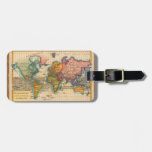
World Map 1700s Antique Luggage Tag
By Antiqueart

World Map 1700s Antique Luggage Tag
Fully customizable World Map 1700s Antique Luggage Tag created by ANTIQUEART. Personalize this product with your own text and images (if the design allows it) and create a gift for yourself, a loved one, for your event or your business. Product Type Aif Luggagetag. Style Small.
World Map from the 1700s -- the Planisphere A highly colorful world map from the 1700s, this world map print is from an authentic map originally published in 1780. It shows the world in vibrant full color. The world map continents are quite well rendered for being drawn 250 years ago. This beautiful world map's illustrator drew North America in green. Central and South America are in a bright yellow, Africa is a dark green, Europe and Australia in orange, and Asia and Greenland in pink. Beautifully rendered, this world map is a gorgeous image from a time when map making was an art. About "The Planisphere" world map image- The actual title of the image is "Planisphere Suivant la Projection de Mercator", published in Paris by M. Bonne in 1780. The Planisphere world map was originally printed as a copper engraving, and later hand colored in outline and wash.
The Most Popular Gifts By Antiqueart | ||
|---|---|---|
 |
 |
 |
 |
 |
 |
 |
 |
 |
 |
 |
 |
Browse this Designer's Gallery: All Products
Browse This Designer's Store at Zazzle: Most Popular